Before Arkansas was a territory, the land
known today as Arkansas was a part of
the Missouri Territory. In January 1815,
the Missouri Territorial Assembly established Lawrence County, consisting of
roughly the northern half of present-day
Arkansas and a portion of southern
Missouri. Missouri Governor William
Clark then appointed commissioners
to choose a suitable place on which to
erect public buildings and establish the
permanent seat of justice. The commissioners located and purchased a piece
of land on the banks of the Black River
from five Frenchmen.
It was decided that this town would not
develop as a random collection of houses and businesses, but instead would
be laid out according to a surveyed
plan. Thus, Davidsonville became the
first platted (or planned) town in what
would later be known as Arkansas. The
plan consisted of a large public square surrounded by eight blocks, each containing
six lots, and a strip of land referred to as “the
commons” that lay between the town and
the Black River. The streets of Davidsonville
were carefully surveyed to be 57 and 3/4 feet
wide, indicating the town planners expected
Davidsonville to grow into a bustling, prosperous city. Davidsonville is the site of the earliest post office in Arkansas, with Adam
Ritchey officially appointed Postmaster
on June 28, 1817. Ritchey was the first of
five postmasters at Davidsonville. Mail
arrived by horseback roughly every 30
days en route from St. Louis to Arkansas Post. Completed in 1822, the two story brick courthouse in Davidsonville
was the first in the state. Although the
court house was not finished until 1822,
court had already been held in private
homes and businesses in Davidsonville. On July 8, 1818, the first Lawrence
County court session was recorded.
Stephen F. Austin, famed as the founder
of Texas, briefly presided over the Lawrence County Circuit Court before heading on to Texas. Court continued to meet
in the Lawrence County Courthouse at
Davidsonville until 1829. Many original,
handwritten court records from Davidsonville still exist today. .JPG) |
| Davidsonville Historic State Park Visitor Center |
None of the original structures of Davidsonville remain today. The layout of the Davidsonville Town Site is demarcated by sign posts identifying the corners of the town streets. Steel "ghost structures" have been erected around the site to provide a visual perspective of the size and location of important structures.
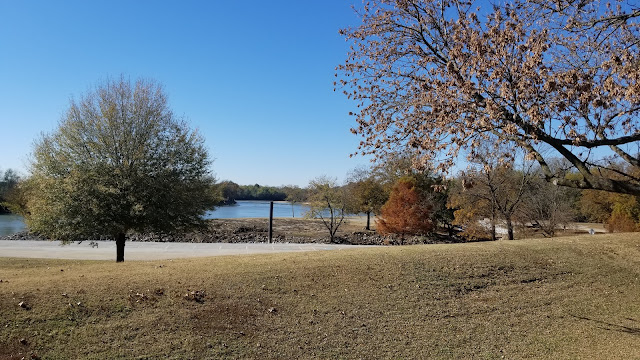
Wednesday morning I was able to take some drone photos and video around the campground. There was still some pretty fall color in the trees.
.JPG) |
| Site #70 |
Rapid growth and community development marked the
period following 1869. Upon selection of Powhatan
as county seat, three commissioners were selected to
choose the site for a new courthouse. The first courthouse, completed in 1873, burned in 1885. Due to
the commission's foresight of buying a fireproof vault,
county records were saved, some dating to 1813.
The citizens erected a second two-story courthouse,
built with brick salvaged from the first courthouse, and
additional new brick for the façade, on the same foundation, laying the cornerstone on May 10, 1888.
In 1963, voters consolidated two county seats into one
at Walnut Ridge, and in 1966, county officials departed
Powhatan for the last time. In 1968, Governor Winthrop
Rockefeller sent a team of specialists from Williamsburg, Virginia, to visit and evaluate the building’s potential. Shortly thereafter, the Lawrence County Development Council and the Powhatan Courthouse Restoration
Committee formed to raise funds for restoration.
The courthouse was placed on the National Register of
Historic Places in February of 1970. Restoration began
in January of 1971 and ended in 1973.
Long before the city of Powhatan was incorporated in 1853, the Osage Indians occupied the area. ln 1817, the Federal Government moved them to reservations outside the state. The first steamboat to arrive at Powhatan "The Laurel" was in 1829. Cargo and passengers arrived and embarked from sternwheelers and keel boats, and crossed the rivers on ferries. Ficklin Ferry, on the Black River, was once described as "the most accessible point at all seasons of the year from Jacksonport to Pocahontas." In 1837, John Ficklin established a ferry on the Black River and built a house on the hill northwest of the ferry. Historians give Ficklin credit as the town’s founder. This ferry, later called the Powhatan Ferry, increased in importance into the 1880s, and helped make Powhatan the chief shipping point for a large territory. Steamboat passengers boarded at Powhatan to travel down the Black and White Rivers, then up or down the Mississippi to their final destinations. Steamboats carried passenger and cargo of timber, cotton, game and anything that needed moving from one place to another. Powhatan began its decline when the Frisco Railroad bypassed the town, roads improved, and rail travel began to overtake river passage as the preferred method of transportation.
%20-%20Copy.JPG)
%20-%20Copy.JPG)
.JPG)
.JPG)
The courthouse sits atop a hill which according to the park interpreter is the beginning of the Ozark mountains. At the the base of the hill you can stand with one foot in the Mississippi delta and the other in the Ozark mountains.
For lunch Wednesday we went into Walnut Ridge and found The Post Bakery and Bistro. The building was built in 1935 and served as the Walnut Ridge Post office until 1977 when a new post office was built. It was then sold to the Times Dispatch newspaper and housed their offices and printing press. No major exterior or interior
changes were required for this new usage and the building is now on the National Register of Historic Places for its local significance. The Post Bakery and Bistro now occupies the building where we had delicious lunch and returned the next day for coffee and a sample of their baked goods.
.jpg)
.jpg)
.jpg)
.jpg)
Crowley's Ridge State park was our first stop of the day. Left as an erosional remnant from the natural forces
of rivers 40 million years ago, Crowley’s Ridge stands
100 to 200 feet above the fertile plains of the Delta in
eastern Arkansas. The ridge was named for Benjamin
F. Crowley, a soldier during the War of 1812 whose land
grant was the first pioneer settlement in this part of the
state. Crowley’s Ridge forms a narrow arc of scenic
rolling hills extending from Cape Girardeau, Missouri
into the northeast corner of Arkansas down to the
Mississippi River at Helena.
Located near Paragould in lower
Greene County at the site of Benjamin
Crowley’s original homesite, Crowley’s
Ridge State Park is situated on the
western slopes of the ridge amid
stately pines and hardwoods. Once a
campground for Native Americans, the
park offers visitors swimming and fishing
in spring-fed lakes, shaded campground and picnic
areas, and scenic nature trails. The park was constructed
by the Civilian Conservation Corps (CCC) beginning
in 1933, establishing it as one of the six original state
parks in Arkansas. Today, those original native stone
and wood structures create a setting of rustic serenity
among the natural surroundings.
.JPG)
.JPG)
.HEIC)
.JPG)
.JPG)
.JPG)
.JPG)
.JPG)
.JPG)
.jpg)
.jpg)
.jpg)
.jpg)
.jpg)
.jpg)
The picture below is what happens when an old fat guy sets a 10 second time delay for a photo but doesn't have time to run around the fence and through the gate to get in the picture. Finally made it work by starting my the timer and starting my run from the same side of the fence where Donna was standing.

.JPG)
Lake Frierson State Park was out second stop on Thursday adventure. Located just 10 miles north of Jonesboro, Lake
Frierson State Park is a haven for both fishermen and
nature-lovers alike. This beautiful 114-acre park is
situated atop scenic Crowley's Ridge, a unique
geological phenomenon which rises 100-200 feet
above the surrounding delta and stretches from Cape
Girardeau, Missouri to Helena, Arkansas. The park
sits on the eastern shore of Lake Frierson, a 335-acre
fishing lake managed by the Arkansas Game & Fish
Commission. Excellent catches of bass, bream,
crappie and catfish are routinely reported. Since 1975,
Lake Frierson State park has provided both recreation
and environmental education to park visitors.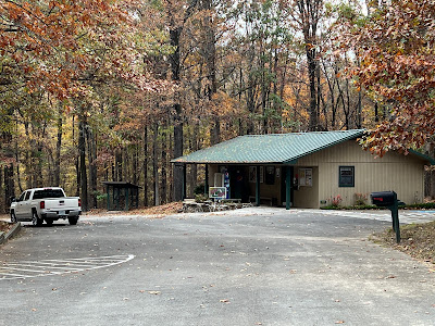.JPG) |
| Lake Frierson State Park Visitor Center |
Lake Walcott is located across the highway from Lake Frierson State Park.
After packing up camp on Friday we headed south on highway 67. We stopped at Newport for a visit to Jacksonport State Park. Jacksonport was an important trade center in early
Arkansas due to its location near the confluence of
the Black and White Rivers. In 1834, Thomas Todd
Tunstall purchased land where he later established
the town of Jacksonport. As the area prospered
and grew, the town developed into a busy steamboat port and became the county seat in 1854.
Steamboats from the Arkansas and Mississippi
Rivers landed at the town year-round loaded with
timber, bear grease, cotton bales, and wild game.
During the Civil War, Jacksonport was occupied
by both Confederate and Union armies due to its
strategic location. Five generals used the town as
their headquarters. On June 5, 1865, Confederate
General Jeff Thompson, “Swampfox of the Confederacy,” surrendered more than 5,000 troops to Lt.
Colonel C. W. Davis at the Jacksonport steamboat
landing.
John A. Schnabel constructed the brick courthouse
with a limestone foundation from 1869 to 1872. The
massive beams supporting the mansard roof are
hand-hewn from the heartwood of native cypress.
The courthouse opened for business in 1872 with
the main entrance facing the White River and the
town's business district on Jefferson Street. Goldentongued oratory once rang through the halls, and
political “speakings” were given from the balconies.
The spacious courtroom hosted both dreadful
murder trials and Mardi Gras balls.
The Iron Mountain & Southern Railroad began
laying track through Jackson County—but not
through this town—in the 1870s. As the railroad
industry prospered and steamboat transportation
declined, Jacksonport slowly began to die without
railroad access. A spur was later added, but it was
too late to save the town.
For 25 years Jacksonport continued to be an
important steamboat landing, and though the
town kept its faith in the river, trade and life
eventually passed it by.
The county seat moved
to Newport in 1892, and Jefferson Street, with its
mercantile houses, wharves, livery stables, and
saloons, slowly vanished.
In 1962, the Jackson County Historical Society
purchased the Jacksonport Courthouse with
privately donated funds. Restoration began the
next year. In 1964, a portion of the town including
the courthouse square and the steamboat landing
was bought by the society. Jacksonport opened
as a state park in 1965. The Arkansas Department
of Parks, Heritage & Tourism has continued
restoration and development of the park with
the support of the historical society. In 1970, the
courthouse was placed on the National Register
of Historic Places. In 2019, a new visitor center was
constructed.
.JPG) |
| Jacksonport State Park Visitor Center |
.jpg) |
| Steamboat Ronnie |
.jpg) |
| The White River at Jacksonport |

.JPG)
.JPG)
.JPG)
.JPG)
.JPG)
.JPG)
.JPG)
.JPG)
.JPG)
.JPG)
.JPG)
.JPG)
.JPG)
.jpg)
.jpg)
.JPG)
.JPG)
.JPG)
.JPG)
.JPG)
.jpg)
.JPG)
.JPG)
.jpg)
.JPG)
.jpg)
.JPG)
.JPG)
.JPG)
.JPG)
.JPG)
.JPG)
.JPG)
.JPG)
.JPG)
.JPG)
.JPG)
.JPG)
.JPG)
.JPG)
.JPG)
.JPG)
.jpg)
.jpg)
.jpg)
.jpg)
.jpg)
.jpg)
.jpg)
.jpg)
.JPG)
.JPG)
.JPG)
.JPG)
.JPG)
.JPG)
.JPG)
.jpg)
.JPG)
.JPG)
.JPG)
.jpg)
.jpg)
.jpg)
.jpg)
.jpg)
.jpg)
.jpg)
.jpg)
.jpg)
.jpg)
.jpg)
.jpg)
.jpg)
.jpg)
.jpg)
.jpg)
.jpg)
.jpg)
.jpg)
.jpg)
.jpg)
.JPG)
.JPG)
.JPG)
.JPG)
.JPG)
.JPG)
.JPG)
.JPG)
%20-%20Copy.JPG)
%20-%20Copy.JPG)
%20-%20Copy.JPG)
%20-%20Copy.JPG)
.JPG)
.JPG)
.JPG)
.JPG)
.JPG)
.JPG)
.JPG)
.JPG)
.JPG)
.JPG)
.JPG)
.jpg)
.jpg)
.jpg)
.jpg)
.JPG)
.JPG)
.HEIC)
.jpg)
.JPG)
.JPG)
.JPG)
.JPG)
.JPG)
.JPG)
.JPG)
.jpg)
.jpg)
.jpg)
.jpg)
.jpg)
.jpg)

.JPG)
.JPG)
.JPG)
.JPG)
.JPG)
.JPG)
.jpg)
.jpg)
.HEIC)
.HEIC)
.JPG)
.jpg)
.jpg)
.JPG)
.JPG)
.JPG)
.JPG)
.jpg)
.JPG)
.jpg)
.jpg)
.jpg)
.JPG)
.JPG)
.JPG)
.JPG)
.JPG)
.JPG)
.JPG)
.JPG)
.JPG)
.JPG)
.jpg)
.jpg)
.jpg)
.jpg)
.jpg)
.jpg)
.jpg)
.jpg)
.jpg)
.jpg)
.jpg)
.jpg)
.jpg)
.jpg)
.jpg)
.jpg)
.jpg)
.jpg)
.jpg)
.jpg)
.jpg)
.jpg)
.jpg)
.jpg)
.jpg)
.jpg)
.jpg)
.jpg)
.jpg)
.jpg)
.jpg)
.jpg)
.jpg)
.jpg)